Project History
California land managers, public servants, and stewards have the responsibility of caring for some of the most populated, but also most ecologically rich and beloved places in the United States, if not the world. Nowhere is this more evident than in the Bay Area whose wild and working lands provide residents and visitors with income, water, varied recreation opportunities, scenic vistas, wildlife habitat, and vital refuges for many threatened, endangered, and special status species. The Bay Area’s resources provide numerous ecological, economic, and social benefits which are vitally interlinked to their communities. The region is a biodiversity hotspot but also home to nearly eight million people.
Growing populations, global climate change, altered fire regimes, invasive/non-native plants and animals, habitat fragmentation, plant diseases and pathogens, noise, light, and air pollution, and other human and natural impacts threaten the health of the area’s natural and man-made resources. To effectively care for the counties’ ecosystems and infrastructure, citizens, landowners, politicians, managers, and government agencies must know the location and distribution of resources across the landscape, and they must monitor change over time.
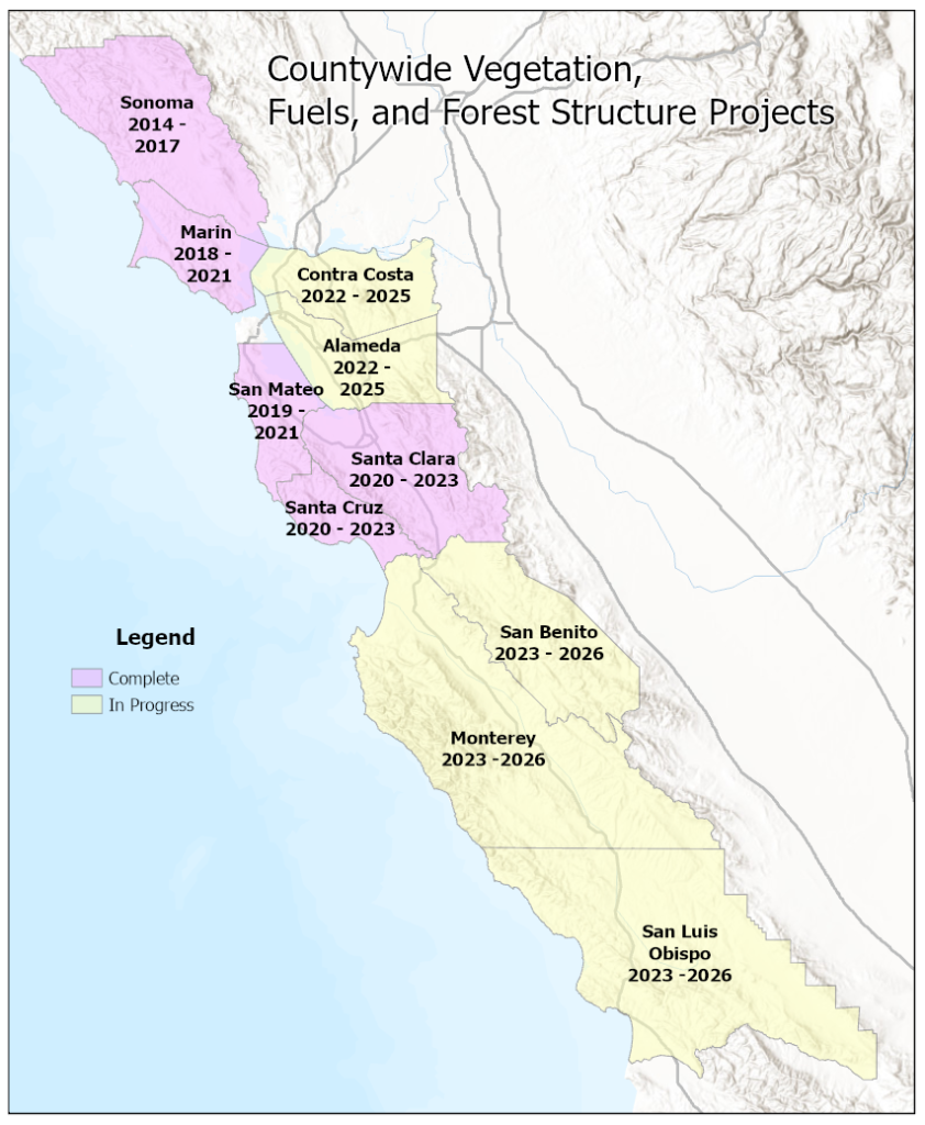 To fulfil these needs, several consortia developed to provide this critical information. Sonoma’s Ag + Open Space District led the first Bay Area vegetation and landscape program.
Shortly after the Sonoma County project was completed in 2017, One Tam, a network of organizations that steward Mount Tamalpais in Marin County, decided to move forward with a similar project in Marin County. The National Parks Service, which is both a One Tam partner and also manages lands in San Mateo County as part of the Golden Gate National Recreation Area, was keen to see the Marin effort expand into San Mateo County. NPS, with support from their non-profit partner the Golden Gate National Parks Conservancy, was able to build a consortium to fund and implement a parallel countywide effort in San Mateo. The Marin County maps were completed in May of 2021, with San Mateo scheduled for completion in January of 2022. Figure 1 shows the counties where recent mapping has occurred.
Primarily because of the usefulness of the Sonoma County data in understanding the behavior of the Sonoma County 2017 Complex wildfires, a fourth consortium, the Santa Cruz Mountains Stewardship Network, expressed interest in a similar mapping project for Santa Cruz and Santa Clara Counties. These projects were completed in 2023. In addition, the Napa County Firewise Foundation embarked in 2019 on a project to use the existing fine scale vegetation map for Napa County developed by UC Davis (Dr. Jim Thorne) and CDFW to create a 5-meter fuel model for Napa County. The fuel model was an integral component of the 2020 countywide CWPP for Napa County.
In 2022, East Bay Regional Parks, in partnership with CDFW, initiated a fine scale vegetation mapping project in Alameda and Contra Costa Counties. Lifeform, fuels and wildfire related data products have been produced and the fine scale vegetation map is due out in 2025.
In 2023, the Coastal San Luis Resource Conservation District, in partnership with CDFW, initiated a fine scale vegetation mapping project for Monterey, San Benito, and San Luis Obispo Counties. Interim mapping products will be available starting in 2024, with the final fine scale vegetation maps expected in 2026.
The benefit of region wide, consistent, fine scale mapping developed across the region cannot be overstated. This consistency is imposed through all of the projects’ reliance on standardized map classification schemes, with the wildland fuels mapped to the nationwide Scott and Burgen (2005) fuels models, and the vegetation classification schemes developed by the California Native Plant Society and the California Department of Fish and Wildlife. The data support on the ground management decisions, but also cross county planning and disaster response.
All of the map products of these efforts are accessible via this web site and are freely available to everyone. The site will be continually updated to include new products as they are completed.
To fulfil these needs, several consortia developed to provide this critical information. Sonoma’s Ag + Open Space District led the first Bay Area vegetation and landscape program.
Shortly after the Sonoma County project was completed in 2017, One Tam, a network of organizations that steward Mount Tamalpais in Marin County, decided to move forward with a similar project in Marin County. The National Parks Service, which is both a One Tam partner and also manages lands in San Mateo County as part of the Golden Gate National Recreation Area, was keen to see the Marin effort expand into San Mateo County. NPS, with support from their non-profit partner the Golden Gate National Parks Conservancy, was able to build a consortium to fund and implement a parallel countywide effort in San Mateo. The Marin County maps were completed in May of 2021, with San Mateo scheduled for completion in January of 2022. Figure 1 shows the counties where recent mapping has occurred.
Primarily because of the usefulness of the Sonoma County data in understanding the behavior of the Sonoma County 2017 Complex wildfires, a fourth consortium, the Santa Cruz Mountains Stewardship Network, expressed interest in a similar mapping project for Santa Cruz and Santa Clara Counties. These projects were completed in 2023. In addition, the Napa County Firewise Foundation embarked in 2019 on a project to use the existing fine scale vegetation map for Napa County developed by UC Davis (Dr. Jim Thorne) and CDFW to create a 5-meter fuel model for Napa County. The fuel model was an integral component of the 2020 countywide CWPP for Napa County.
In 2022, East Bay Regional Parks, in partnership with CDFW, initiated a fine scale vegetation mapping project in Alameda and Contra Costa Counties. Lifeform, fuels and wildfire related data products have been produced and the fine scale vegetation map is due out in 2025.
In 2023, the Coastal San Luis Resource Conservation District, in partnership with CDFW, initiated a fine scale vegetation mapping project for Monterey, San Benito, and San Luis Obispo Counties. Interim mapping products will be available starting in 2024, with the final fine scale vegetation maps expected in 2026.
The benefit of region wide, consistent, fine scale mapping developed across the region cannot be overstated. This consistency is imposed through all of the projects’ reliance on standardized map classification schemes, with the wildland fuels mapped to the nationwide Scott and Burgen (2005) fuels models, and the vegetation classification schemes developed by the California Native Plant Society and the California Department of Fish and Wildlife. The data support on the ground management decisions, but also cross county planning and disaster response.
All of the map products of these efforts are accessible via this web site and are freely available to everyone. The site will be continually updated to include new products as they are completed.
Contributing Organizations